# Earthdata Login
from netrc import netrc
from subprocess import Popen
from platform import system
from getpass import getpass
import os

# Direct access
import requests
import s3fs
import xarray as xr
import hvplot.xarray

# Harmony
from harmony import BBox, Client, Collection, Request, LinkType
from harmony.config import Environment
from pprint import pprint
import datetime as dtEarthdata Cloud Exploration: Direct Access and Harmony workflow
Summary
This notebook will walk through two different access and transformation options across a single dataset available in the Earthdata Cloud: Direct s3 access and Harmony transformation services. These steps are based off of several notebook tutorials presented during the 2021 Earthdata Cloud Hackathon and 2021 AGU Workshop.
The following use case focuses on Sea Surface Temperature (SST) from the GHRSST MODIS L2 dataset (MODIS_T-JPL-L2P-v2019.0) available from PO.DAAC in the Earthdata Cloud.
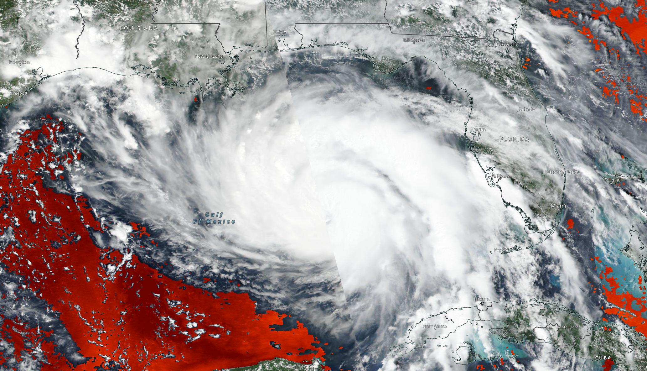
Hurricane Ida snapshot
Using NASA Worldview, we can first explore SST during a tropical storm event; in this case, we can overlay L2 and L4 SST variables against true color imagery to observe Hurricane Ida in August 2021. Although this is a small sample set, this use case could be expanded to explore how SST responds during the Atlantic hurricane over the next several months. The same data that we are requesting below using direct s3 access and via Harmony-py can also be requested using NASA Earthdata Search
We will access a single netCDF file from inside the AWS cloud (us-west-2 region, specifically) and load it into Python as an xarray dataset. This approach leverages S3 native protocols for efficient access to the data.
After inspecting the data, we will then access the same file, but in this case we will also subset the data to our area of interest using Harmony.
Import Required Packages
1. Authentication for NASA Earthdata
Based off of https://nasa-openscapes.github.io/2021-Cloud-Workshop-AGU/tutorials/02_NASA_Earthdata_Authentication.html
First, we will create a hidden .netrc file (_netrc for Window OS) with Earthdata login credentials in your home directory. This file is needed to access NASA Earthdata assets from a scripting environment like Python.
Earthdata Login
An Earthdata Login account is required to access data, as well as discover restricted data, from the NASA Earthdata system. Thus, to access NASA data, you need Earthdata Login. Please visit https://urs.earthdata.nasa.gov to register and manage your Earthdata Login account. This account is free to create and only takes a moment to set up.
Authentication via netrc File
You will need a netrc file containing your NASA Earthdata Login credentials in order to execute the notebooks. A netrc file can be created manually within text editor and saved to your home directory. An example of the required content is below.
machine urs.earthdata.nasa.gov
login <USERNAME>
password <PASSWORD>
<USERNAME> and <PASSWORD> would be replaced by your actual Earthdata Login username and password respectively.
The code below will:
- check what operating system (OS) is being used to determine which netrc file to check for/create (.netrc or _netrc)
- check if you have an netrc file, and if so, varify if those credentials are for the Earthdata endpoint
- create a netrc file if a netrc file is not present.
urs = 'urs.earthdata.nasa.gov'    # Earthdata URL endpoint for authentication
prompts = ['Enter NASA Earthdata Login Username: ',
           'Enter NASA Earthdata Login Password: ']

# Determine the OS (Windows machines usually use an '_netrc' file)
netrc_name = "_netrc" if system()=="Windows" else ".netrc"

# Determine if netrc file exists, and if so, if it includes NASA Earthdata Login Credentials
try:
    netrcDir = os.path.expanduser(f"~/{netrc_name}")
    netrc(netrcDir).authenticators(urs)[0]

# Below, create a netrc file and prompt user for NASA Earthdata Login Username and Password
except FileNotFoundError:
    homeDir = os.path.expanduser("~")
    Popen('touch {0}{2} | echo machine {1} >> {0}{2}'.format(homeDir + os.sep, urs, netrc_name), shell=True)
    Popen('echo login {} >> {}{}'.format(getpass(prompt=prompts[0]), homeDir + os.sep, netrc_name), shell=True)
    Popen('echo \'password {} \'>> {}{}'.format(getpass(prompt=prompts[1]), homeDir + os.sep, netrc_name), shell=True)
    # Set restrictive permissions
    Popen('chmod 0600 {0}{1}'.format(homeDir + os.sep, netrc_name), shell=True)

    # Determine OS and edit netrc file if it exists but is not set up for NASA Earthdata Login
except TypeError:
    homeDir = os.path.expanduser("~")
    Popen('echo machine {1} >> {0}{2}'.format(homeDir + os.sep, urs, netrc_name), shell=True)
    Popen('echo login {} >> {}{}'.format(getpass(prompt=prompts[0]), homeDir + os.sep, netrc_name), shell=True)
    Popen('echo \'password {} \'>> {}{}'.format(getpass(prompt=prompts[1]), homeDir + os.sep, netrc_name), shell=True)
See if the file was created
If the file was created, we’ll see a .netrc file (_netrc for Window OS) in the list printed below. To view the contents from a Jupyter environment, click File on the top toolbar, select Open from Path…, type .netrc, and click Open. The .netrc file will open within the text editor.
!!! Beware, your password will be visible if the
.netrcfile is opened in the text editor.
!ls -al ~/2. Accessing a NetCDF4/HDF5 File - S3 Direct Access
_Based off of https://nasa-openscapes.github.io/2021-Cloud-Workshop-AGU/how-tos/Earthdata_Cloud__Single_File_Direct_S3_Access_NetCDF4_Example.html and https://nasa-openscapes.github.io/2021-Cloud-Workshop-AGU/tutorials/04_On-Prem_Cloud.html
Summary
We will access a single netCDF file from the GHRSST MODIS L2 dataset (MODIS_T-JPL-L2P-v2019.0) inside the AWS cloud (us-west-2 region, specifically) and load it into Python as an xarray dataset. This approach leverages S3 native protocols for efficient access to the data.
Requirements
1. AWS instance running in us-west-2
NASA Earthdata Cloud data in S3 can be directly accessed via temporary credentials; this access is limited to requests made within the US West (Oregon) (code: us-west-2) AWS region.
2. Earthdata Login
3. netrc File
Learning Objectives
- how to retrieve temporary S3 credentials for in-region direct S3 bucket access
- how to define a dataset of interest and find netCDF files in S3 bucket
- how to perform in-region direct access of MODIS_T-JPL-L2P-v2019.0 data in S3
- how to plot the data
Get Temporary AWS Credentials
Direct S3 access is achieved by passing NASA supplied temporary credentials to AWS so we can interact with S3 objects from applicable Earthdata Cloud buckets. For now, each NASA DAAC has different AWS credentials endpoints. Below are some of the credential endpoints to various DAACs:
s3_cred_endpoint = {
    'podaac':'https://archive.podaac.earthdata.nasa.gov/s3credentials',
    'gesdisc': 'https://data.gesdisc.earthdata.nasa.gov/s3credentials',
    'lpdaac':'https://data.lpdaac.earthdatacloud.nasa.gov/s3credentials',
    'ornldaac': 'https://data.ornldaac.earthdata.nasa.gov/s3credentials',
    'ghrcdaac': 'https://data.ghrc.earthdata.nasa.gov/s3credentials'
}
Create a function to make a request to an endpoint for temporary credentials. Remember, each DAAC has their own endpoint and credentials are not usable for cloud data from other DAACs.
def get_temp_creds(provider):
    return requests.get(s3_cred_endpoint[provider]).json()
temp_creds_req = get_temp_creds('podaac')
#temp_creds_reqSet up an s3fs session for Direct Access
s3fs sessions are used for authenticated access to s3 buckets and allow for typical file-system style operations. Below we create session by passing in the temporary credentials we recieved from our temporary credentials endpoint.
fs_s3 = s3fs.S3FileSystem(anon=False,
                          key=temp_creds_req['accessKeyId'],
                          secret=temp_creds_req['secretAccessKey'],
                          token=temp_creds_req['sessionToken'],
                          client_kwargs={'region_name':'us-west-2'})
In this example we’re interested in the GHRSST MODIS L2 collection from NASA’s PO.DAAC in Earthdata Cloud. Below we specify the s3 URL to the data asset in Earthdata Cloud. This URL can be found via Earthdata Search or programmatically through the CMR and CMR-STAC APIs.
short_name = 'MODIS_T-JPL-L2P-v2019.0'
s3_url = 's3://podaac-ops-cumulus-protected/MODIS_T-JPL-L2P-v2019.0/20210820033500-JPL-L2P_GHRSST-SSTskin-MODIS_T-N-v02.0-fv01.0.nc'
Direct In-region Access
Open with the netCDF file using the s3fs package, then load the cloud asset into a concatenated xarray dataset.
s3_file_obj = fs_s3.open(s3_url, mode='rb')ssh_ds = xr.open_dataset(s3_file_obj)
ssh_ds<xarray.Dataset>
Dimensions: (nj: 2030, ni: 1354, time: 1)
Coordinates:
lat (nj, ni) float32 ...
lon (nj, ni) float32 ...
* time (time) datetime64[ns] 2021-08-20T03:35:00
Dimensions without coordinates: nj, ni
Data variables:
sea_surface_temperature (time, nj, ni) float32 ...
sst_dtime (time, nj, ni) timedelta64[ns] ...
quality_level (time, nj, ni) float32 ...
sses_bias (time, nj, ni) float32 ...
sses_standard_deviation (time, nj, ni) float32 ...
l2p_flags (time, nj, ni) int16 ...
sea_surface_temperature_4um (time, nj, ni) float32 ...
quality_level_4um (time, nj, ni) float32 ...
sses_bias_4um (time, nj, ni) float32 ...
sses_standard_deviation_4um (time, nj, ni) float32 ...
wind_speed (time, nj, ni) float32 ...
dt_analysis (time, nj, ni) float32 ...
Attributes: (12/49)
Conventions: CF-1.7, ACDD-1.3
title: MODIS Terra L2P SST
summary: Sea surface temperature retrievals produced a...
references: GHRSST Data Processing Specification v2r5
institution: NASA/JPL/OBPG/RSMAS
history: MODIS L2P created at JPL PO.DAAC
... ...
publisher_email: ghrsst-po@nceo.ac.uk
processing_level: L2P
cdm_data_type: swath
startDirection: Ascending
endDirection: Ascending
day_night_flag: NightLet’s make a quick plot to take a look at the sea_surface_temperature variable.
ssh_ds.sea_surface_temperature.plot() ;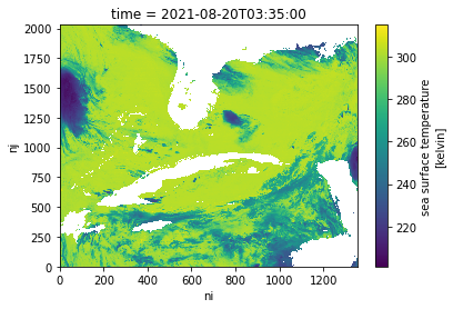
3. Accessing Multiple NetCDF4/HDF5 Files - Data Subsetting and Transformation Services in the Cloud
Using the Harmony-Py library to access customized data from NASA Earthdata
What other access options or services exist for this dataset?
Maybe we’re interested in creating a time series over a larger area or with a larger dataset. Let’s see whether there are other services out there that could either make this operation more performant in the cloud (with a cloud-optimized output) or subsetting services to reduce the data volume.
Based off of https://nasa-openscapes.github.io/2021-Cloud-Hackathon/tutorials/07_Harmony_Subsetting.html
Summary
We have already explored direct access to the NASA EOSDIS archive in the cloud via the Amazon Simple Storage Service (S3) by using the Common Metadata Repository (CMR) to search for granule locations. In addition to directly accessing the files archived and distributed by each of the NASA DAACs, many datasets also support services that allow us to customize the data via subsetting, reformatting, reprojection, and other transformations.
This tutorial demonstrates how to find, request, and use customized data from a new ecosystem of services operating within the NASA Earthdata Cloud: NASA Harmony.
Benefits
But first, why use this option when we’ve already learned how to access data directly from the NASA Earthdata Cloud?
- Consistent access patterns to EOSDIS holdings make cross-data center data access easier
- Data reduction services allow us to request only the data we want, in the format and projection we want
- Analysis Ready Data and cloud access will help reduce time-to-science
- Community Development helps reduce the barriers for re-use of code and sharing of domain knowledge
See more on the Earthdata Harmony landing page, including documentation on the Harmony API itself.
Objectives
- Conceptualize the data transformation service types and offerings provided by NASA Earthdata, including Harmony.
- Practice skills learned from the introductory CMR tutorial to discover what access and service options exist for a given data set, as well as variable metadata.
- Utilize the Harmony-py library to request subsetted MODIS L2 Sea Surface Temperature data over the Gulf of Mexico.
- Read Harmony subsetted outputs directly into xarray.
Discover service options for a given data set
First, what do we mean by a “service”?
In the context of NASA Earthdata, we are usually referring to a service as any data transformation or customization process that packages or delivers data in a way that makes it easier to work with compared to how the data are natively archived at NASA EOSDIS. Basic customization options may include: * Subsetting (cropping) the data by: * Variable * Spatial boundary, * Temporal range * Reformatting * For example: From NetCDF-4 to Cloud Optimized GeoTIFF * Reprojection and/or Resampling * For example: From Sinusoidal to Polar Stereographic * Mosaicking * Aggregating
A few main types or pathways for services that are commonly supported across the NASA DAACs include: * NASA Global Imagery Browse Service * Web services providing imagery, much of which is updated daily, to broaden availability of NASA EOSDIS data to the media and public. * OPeNDAP * The Open-source Project for a Network Data Access Protocol is a NASA community standard DAP that provides a simple way to access and work with data over the internet. OPeNDAP’s client/server software allows us to subset and reformat data using an internet browser, command line interface, and other applications. * Harmony * In the most basic sense, Harmony is an Application Programming Interface, or API, allowing us to request customization options described above, which are then processed and returned as file outputs. Harmony helps to reduce pre-processing steps so we can spend less time preparing the data, and more time doing science.
Note: These service offerings are unique to each NASA EOSDIS dataset.
Why is this?
Due to varying levels of service, cloud migration status, and unique characteristics of the datasets themselves, not all service options are provided for all datasets. Therefore it is important to first explore a given dataset’s metadata to discover what service options are provided.
Note that the full Harmony tutorial from the 2021 Earthdata Cloud Hackathon demonstrates service and variable discovery, but this was removed here for simplification.
Using Harmony-Py to subset data
Harmony-Py provides a pip installable Python alternative to directly using Harmony’s RESTful API to make it easier to request data and service options, especially when interacting within a Python Jupyter Notebook environment.
The next steps are adopted from the introduction tutorial notebook provided in the Harmony-Py library:
Create Harmony Client object
First, we need to create a Harmony Client, which is what we will interact with to submit and inspect a data request to Harmony, as well as to retrieve results.
When creating the Client, we need to provide Earthdata Login credentials, which are required to access data from NASA EOSDIS. This basic line below assumes that we have a .netrc available.
harmony_client = Client()Create Harmony Request
The following are common request parameters:
collection: Required parameter. This is the NASA EOSDIS collection, or data product. There are two options for inputting a collection of interest:- Provide a concept ID (e.g. C1940473819-POCLOUD)
- Data product short name (e.g. MODIS_A-JPL-L2P-v2019.0).
spatial: Bounding box spatial constraints on the data. The Harmony Bbox class accepts spatial coordinates as decimal degrees in w, s, e, n order, where longitude = -180, 180 and latitude = -90, 90.temporal: Date/time constraints on the data. The example below demonstrates temporal start and end ranges using the python datetime library.
As we identified above, only subsetting options are available for this dataset. If other service options such as reformatting are available for a given dataset, these can also be specified using Harmony-py: See the documentation for details on how to construct these parameters.
request = Request(
    collection=Collection(id=short_name),
    spatial=BBox(-97.77667,21.20806,-83.05197,30.16605),
    temporal={
        'start': dt.datetime(2021, 8, 20),
        'stop': dt.datetime(2021, 8, 21),
    },
)
Submit request
Now that the request is created, we can now submit it to Harmony using the Harmony Client object. A job id is returned, which is a unique identifier that represents the submitted request.
job_id = harmony_client.submit(request)
job_id'42f70e4f-5e6a-4473-8a5a-4ce56155ce92'Check request status
Depending on the size of the request, it may be helpful to wait until the request has completed processing before the remainder of the code is executed. The wait_for_processing() method will block subsequent lines of code while optionally showing a progress bar.
harmony_client.wait_for_processing(job_id, show_progress=True) [ Processing: 100% ] |###################################################| [|]View Harmony job response and output URLs
Once the data request has finished processing, we can view details on the job that was submitted to Harmony, including the API call to Harmony, and informational messages on the request if available.
result_json() calls wait_for_processing() and returns the complete job in JSON format once processing is complete.
data = harmony_client.result_json(job_id)
pprint(data)
{'createdAt': '2022-03-10T01:08:45.232Z',
'jobID': '42f70e4f-5e6a-4473-8a5a-4ce56155ce92',
'links': [{'href': 'https://harmony.earthdata.nasa.gov/stac/42f70e4f-5e6a-4473-8a5a-4ce56155ce92/',
'rel': 'stac-catalog-json',
'title': 'STAC catalog',
'type': 'application/json'},
{'bbox': [-97.8, 21.2, -90.8, 22.5],
'href': 'https://harmony.earthdata.nasa.gov/service-results/harmony-prod-staging/public/podaac/l2-subsetter/4419d8b3-2127-4c8a-a7ef-2071d589de19/20210820172501-JPL-L2P_GHRSST-SSTskin-MODIS_T-D-v02.0-fv01.0_subsetted.nc4',
'rel': 'data',
'temporal': {'end': '2021-08-20T17:29:59.000Z',
'start': '2021-08-20T17:25:01.000Z'},
'title': '20210820172501-JPL-L2P_GHRSST-SSTskin-MODIS_T-D-v02.0-fv01.0_subsetted.nc4',
'type': 'application/x-netcdf4'},
{'bbox': [-97.8, 21.2, -86.8, 30.2],
'href': 'https://harmony.earthdata.nasa.gov/service-results/harmony-prod-staging/public/podaac/l2-subsetter/4419d8b3-2127-4c8a-a7ef-2071d589de19/20210820172001-JPL-L2P_GHRSST-SSTskin-MODIS_T-D-v02.0-fv01.0_subsetted.nc4',
'rel': 'data',
'temporal': {'end': '2021-08-20T17:24:59.000Z',
'start': '2021-08-20T17:20:01.000Z'},
'title': '20210820172001-JPL-L2P_GHRSST-SSTskin-MODIS_T-D-v02.0-fv01.0_subsetted.nc4',
'type': 'application/x-netcdf4'},
{'bbox': [-88.2, 21.2, -83.1, 28.3],
'href': 'https://harmony.earthdata.nasa.gov/service-results/harmony-prod-staging/public/podaac/l2-subsetter/4419d8b3-2127-4c8a-a7ef-2071d589de19/20210820154501-JPL-L2P_GHRSST-SSTskin-MODIS_T-D-v02.0-fv01.0_subsetted.nc4',
'rel': 'data',
'temporal': {'end': '2021-08-20T15:49:59.000Z',
'start': '2021-08-20T15:45:01.000Z'},
'title': '20210820154501-JPL-L2P_GHRSST-SSTskin-MODIS_T-D-v02.0-fv01.0_subsetted.nc4',
'type': 'application/x-netcdf4'},
{'bbox': [-87.1, 28, -83.1, 30.2],
'href': 'https://harmony.earthdata.nasa.gov/service-results/harmony-prod-staging/public/podaac/l2-subsetter/4419d8b3-2127-4c8a-a7ef-2071d589de19/20210820154001-JPL-L2P_GHRSST-SSTskin-MODIS_T-D-v02.0-fv01.0_subsetted.nc4',
'rel': 'data',
'temporal': {'end': '2021-08-20T15:44:59.000Z',
'start': '2021-08-20T15:40:01.000Z'},
'title': '20210820154001-JPL-L2P_GHRSST-SSTskin-MODIS_T-D-v02.0-fv01.0_subsetted.nc4',
'type': 'application/x-netcdf4'},
{'bbox': [-97.8, 21.2, -94, 30.2],
'href': 'https://harmony.earthdata.nasa.gov/service-results/harmony-prod-staging/public/podaac/l2-subsetter/4419d8b3-2127-4c8a-a7ef-2071d589de19/20210820051501-JPL-L2P_GHRSST-SSTskin-MODIS_T-N-v02.0-fv01.0_subsetted.nc4',
'rel': 'data',
'temporal': {'end': '2021-08-20T05:19:59.000Z',
'start': '2021-08-20T05:15:01.000Z'},
'title': '20210820051501-JPL-L2P_GHRSST-SSTskin-MODIS_T-N-v02.0-fv01.0_subsetted.nc4',
'type': 'application/x-netcdf4'},
{'bbox': [-95.4, 21.2, -83.1, 30.2],
'href': 'https://harmony.earthdata.nasa.gov/service-results/harmony-prod-staging/public/podaac/l2-subsetter/4419d8b3-2127-4c8a-a7ef-2071d589de19/20210820033500-JPL-L2P_GHRSST-SSTskin-MODIS_T-N-v02.0-fv01.0_subsetted.nc4',
'rel': 'data',
'temporal': {'end': '2021-08-20T03:39:59.000Z',
'start': '2021-08-20T03:35:00.000Z'},
'title': '20210820033500-JPL-L2P_GHRSST-SSTskin-MODIS_T-N-v02.0-fv01.0_subsetted.nc4',
'type': 'application/x-netcdf4'},
{'href': 'https://harmony.earthdata.nasa.gov/jobs/42f70e4f-5e6a-4473-8a5a-4ce56155ce92?linktype=https&page=1&limit=2000',
'rel': 'self',
'title': 'The current page',
'type': 'application/json'}],
'message': 'The job has completed successfully',
'numInputGranules': 6,
'progress': 100,
'request': 'https://harmony.earthdata.nasa.gov/MODIS_T-JPL-L2P-v2019.0/ogc-api-coverages/1.0.0/collections/all/coverage/rangeset?forceAsync=true&subset=lat(21.20806%3A30.16605)&subset=lon(-97.77667%3A-83.05197)&subset=time(%222021-08-20T00%3A00%3A00%22%3A%222021-08-21T00%3A00%3A00%22)',
'status': 'successful',
'updatedAt': '2022-03-10T01:09:26.492Z',
'username': 'amy.steiker'}Direct cloud access
Note that the remainder of this tutorial will only succeed when running this notebook within the AWS us-west-2 region.
Harmony data outputs can be accessed within the cloud using the s3 URLs and AWS credentials provided in the Harmony job response.
Retrieve list of output URLs.
The result_urls() method calls wait_for_processing() and returns a list of the processed data URLs once processing is complete. You may optionally show the progress bar as shown below.
results = harmony_client.result_urls(job_id, link_type=LinkType.s3)
urls = list(results)
pprint(urls)
['s3://harmony-prod-staging/public/podaac/l2-subsetter/4419d8b3-2127-4c8a-a7ef-2071d589de19/20210820172501-JPL-L2P_GHRSST-SSTskin-MODIS_T-D-v02.0-fv01.0_subsetted.nc4',
's3://harmony-prod-staging/public/podaac/l2-subsetter/4419d8b3-2127-4c8a-a7ef-2071d589de19/20210820172001-JPL-L2P_GHRSST-SSTskin-MODIS_T-D-v02.0-fv01.0_subsetted.nc4',
's3://harmony-prod-staging/public/podaac/l2-subsetter/4419d8b3-2127-4c8a-a7ef-2071d589de19/20210820154501-JPL-L2P_GHRSST-SSTskin-MODIS_T-D-v02.0-fv01.0_subsetted.nc4',
's3://harmony-prod-staging/public/podaac/l2-subsetter/4419d8b3-2127-4c8a-a7ef-2071d589de19/20210820154001-JPL-L2P_GHRSST-SSTskin-MODIS_T-D-v02.0-fv01.0_subsetted.nc4',
's3://harmony-prod-staging/public/podaac/l2-subsetter/4419d8b3-2127-4c8a-a7ef-2071d589de19/20210820051501-JPL-L2P_GHRSST-SSTskin-MODIS_T-N-v02.0-fv01.0_subsetted.nc4',
's3://harmony-prod-staging/public/podaac/l2-subsetter/4419d8b3-2127-4c8a-a7ef-2071d589de19/20210820033500-JPL-L2P_GHRSST-SSTskin-MODIS_T-N-v02.0-fv01.0_subsetted.nc4']We’ll select a URL in the list to bring into xarray below, which matches the granule we opened directly from PO.DAAC’s archive bucket above. In Earthdata Search, we can see that this granule covers our area well.
filename = '20210820033500-JPL-L2P_GHRSST-SSTskin-MODIS_T-N-v02.0-fv01.0_subsetted.nc4'

url = [url for url in urls if filename in url][0]
url's3://harmony-prod-staging/public/podaac/l2-subsetter/4419d8b3-2127-4c8a-a7ef-2071d589de19/20210820033500-JPL-L2P_GHRSST-SSTskin-MODIS_T-N-v02.0-fv01.0_subsetted.nc4'AWS credential retrieval
Using aws_credentials you can retrieve the credentials needed to access the Harmony s3 staging bucket and its contents.
creds = harmony_client.aws_credentials()Open staged files with s3fs and xarray
We use the AWS s3fs package to create a file system that can then be read by xarray:
s3_fs = s3fs.S3FileSystem(
    key=creds['aws_access_key_id'],
    secret=creds['aws_secret_access_key'],
    token=creds['aws_session_token'],
    client_kwargs={'region_name':'us-west-2'},
)
Now that we have our s3 file system set, including our declared credentials, we’ll use that to open the url, and read in the file through xarray. This extra step is needed because xarray cannot open the S3 location directly. Instead, the S3 file object is passed to xarray, in order to then open the dataset.
f = s3_fs.open(url, mode='rb')
ds = xr.open_dataset(f)
ds
<xarray.Dataset>
Dimensions: (nj: 1228, ni: 660, time: 1)
Coordinates:
lat (nj, ni, time) float32 ...
lon (nj, ni, time) float32 ...
* time (time) datetime64[ns] 2021-08-20T03:35:00
Dimensions without coordinates: nj, ni
Data variables:
sea_surface_temperature (time, nj, ni) float32 ...
sst_dtime (time, nj, ni) timedelta64[ns] ...
quality_level (time, nj, ni) float32 ...
sses_bias (time, nj, ni) float32 ...
sses_standard_deviation (time, nj, ni) float32 ...
l2p_flags (time, nj, ni) int16 ...
sea_surface_temperature_4um (time, nj, ni) float32 ...
quality_level_4um (time, nj, ni) float32 ...
sses_bias_4um (time, nj, ni) float32 ...
sses_standard_deviation_4um (time, nj, ni) float32 ...
wind_speed (time, nj, ni) float32 ...
dt_analysis (time, nj, ni) float32 ...
Attributes: (12/50)
Conventions: CF-1.7, ACDD-1.3
title: MODIS Terra L2P SST
summary: Sea surface temperature retrievals produced a...
references: GHRSST Data Processing Specification v2r5
institution: NASA/JPL/OBPG/RSMAS
history: MODIS L2P created at JPL PO.DAAC\n2022-03-10 ...
... ...
processing_level: L2P
cdm_data_type: swath
startDirection: Ascending
endDirection: Ascending
day_night_flag: Night
history_json: [{"date_time": "2022-03-10T01:09:25.100329+00...Plot the data
Use the xarray built in plotting function to create a simple plot along the x and y dimensions of the dataset:
ds.sea_surface_temperature.plot() ;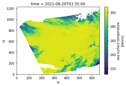
Summary
This notebook demonstrated an abbreviated and simplified workflow to explore access and subsetting options available through the Earthdata Cloud. There are several other options that can be used to work “in place” in the Earthdata Cloud, from data discovery to analysis-ready data, including:
- Zarr-EOSDIS-Store
- The zarr-eosdis-store library allows NASA EOSDIS Collections to be accessed efficiently by the Zarr Python library, provided they have a sidecar DMR++ metadata file generated.
- Tutorial highlighting this library’s usage: https://nasa-openscapes.github.io/2021-Cloud-Hackathon/tutorials/09_Zarr_Access.html
- OPeNDAP
- Hyrax provides direct access to subsetting of NASA data using Python or your favorite analysis tool
- Tutorial highlighting OPeNDAP usage: https://nasa-openscapes.github.io/2021-Cloud-Hackathon/tutorials/06_S6_OPeNDAP_Access_Gridding.html
- Earthdata Library
- A Python library to search and access NASA Earthdata datasets, aiming to provide a simple way to access or download data without having to worry if a given dataset is on-prem or in the cloud.